Statistics Program – V1 Makassar Sea Reclamation in South Sulawesi
The South Sulawesi Provincial Government has a land reclamation project and this plan is contained in the Makassar RT/RTW Handover Regulation No. 4 of 2015. The sea reclamation was built to provide land for urban development with a reclamation target area of 4,000 ha which is planned to be built in coastal areas and Small islands are designated as reclamation targets.
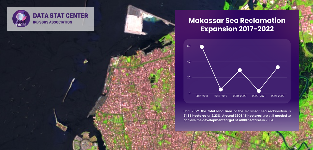
Until 2022, the total land area of Makassar sea reclamation is 91.85 hectares or 2.23%. Around 3908.15 hectares are still needed to achieve the development target of 4000 hectares in 2034. Currently, the officially announced reclamation objects are the Centers Point of Indonesia (CPI) and Makassar New Port (MNP).
.
Source by:
Aslam MF, Fathan Aldi Rivai FA, Alamako WB, Nurhawaillah LE, Asy’Ari R, Setiawan Y, Zamani NP, Pramulya R. 2023. Integration of geospatial data, machine learning algorithms, cloud computing platforms in identifying land-use land-cover (LULC) changes for sea reclamation case studies in Makassar City. SSRS Journal B: Spatial Research. In Review.
.
Edited by Salamah Zuhkrufa J, Data Stat Center Editorial Team
CP: +6285606798907
——–
1/D/4/2/6
#infographic
#datastatcenter
#ipbssrsassocation
#datastatcenter
Directorate of Scientific Publication Media, Innovation, and Strategic Information
IPB SSRS Association
Instagram : @data_stat
Email : publikasiipbssrs@gmail.com
Contact person : Lenny (@sheis.lenka)