Author: Ali Dzulfigar

Statistics, Spatiotemporal and timelapse information

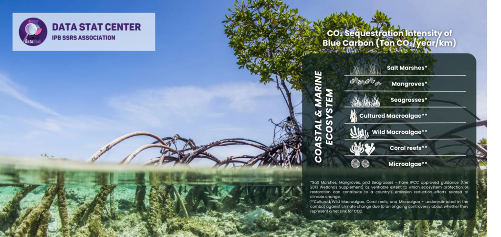
Statistics Program – V9 Global Megacities and Frequent Floods: Correlation Between Urban Expansions Patterns and Urban Flood Hazards

Ever wondered how the world’s largest cities are coping with the dual challenges of rapid urban expansion and increasing flood risks? This visual comparison sheds light on the correlation between urban growth patterns and flood hazards across major megacities like Guangzhou, London, Tokyo, Jakarta, and more. 🌧️🏙️ From the bustling streets of Guangzhou to the…
Read more

Statistics Program – V8 Lapindo Mudflow on Sidoarjo Regency

The Sidoarjo mud flow, commonly known as Lumpur Lapindo, is the result of an erupting mud volcano in the subdistrict of Porong, Sidoarjo, East Java, Indonesia. It has been in eruption since May 2006 and is the largest mud volcano globally. Responsibility for the disaster was assigned to the blowout of a natural gas well…
Read more

Spatiotemporal Program – V9 Grassland Fire and Regrowth at National Park of Mount Bromo Tengger Semeru

🔥🌱 From ashes to life! The National Park of Mount Bromo Tengger Semeru has witnessed a remarkable transformation. After the grassland fire, new growth is emerging, painting the landscape with vibrant greens. This incredible regrowth showcases nature’s resilience and its ability to bounce back even stronger. It’s a powerful reminder of the cycles of destruction…
Read more

Spatiotemporal Program – V8 Lapindo Mudflow on Sidoarjo Regency

The Sidoarjo mud flow, also known as Lumpur Lapindo, is an ongoing environmental disaster in East Java, Indonesia. The mud flow resulted from an erupting mud volcano in the subdistrict of Porong, Sidoarjo. Responsibility was assigned to the blowout of a natural gas well drilled by PT Lapindo Brantas, although company officials contend it was…
Read more

Statistics Program – V7 The distribution of peatland in Europe

The distribution of peatland in Europe is strongly imbalanced, with much more peatland occurring in the north than in the south. The overall area of peatland in Europe is estimated at 593.727 km2 (5,4% of the total surface area). Mires cover more than 320.000 km2 (about 54% of the peatland area). If shallow-peat lands (<…
Read more

Statistics Program – V6 Sequestration Intensity of Blue Carbon

Taking advantage of blue carbon (BC) has been one strategy to mitigate and adapt to global climate change through carbon capture and storage (CCS) in both living and non-living biomass. The ocean has a vast capacity for carbon sequestration, comprising nearly half of the total global CCS. The current BC definition is limiting effective carbon…
Read more